


VicTraffic
Beschreibung von VicTraffic
VicTraffic is the official traffic app from VicRoads.
The app stays up to date by automatically downloading new content when it is available.
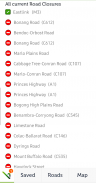
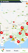
Road Closures and Traffic Alerts are generally uploaded to the application during peak traffic periods of Monday to Friday, 6:45am to 6:45pm and after hours during significant emergency events.
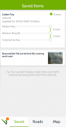
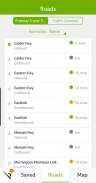
Details include location, impacts and any special instructions such as detours.
Pre-planned interruptions such as Roadwork’s and Events are available up to 48 hours in advance.
Freeway travel times and live traffic camera images from around Melbourne provide you with a live image of how traffic is looking there and then.
Features include:
• Locality Search
• Zoom to your location (location services)
• Customisable settings for different data types
• Region and Municipality filters
VicTraffic ist die offizielle Verkehrs-App von VicRoads.
Die App bleibt auf dem neuesten Stand, indem neue Inhalte automatisch heruntergeladen werden, sobald sie verfügbar sind.
Straßensperrungen und Verkehrswarnungen werden in der Regel während der Hauptverkehrszeiten von Montag bis Freitag von 6:45 bis 18:45 Uhr und außerhalb der Geschäftszeiten während wichtiger Notfälle in die Anwendung hochgeladen.
Zu den Details gehören Standort, Aufprall und spezielle Anweisungen wie Umwege.
Im Voraus geplante Unterbrechungen wie Straßenarbeiten und Veranstaltungen sind bis zu 48 Stunden im Voraus verfügbar.
Freeway-Fahrzeiten und Live-Bilder von Verkehrskameras aus der Umgebung von Melbourne bieten Ihnen ein Live-Bild davon, wie der Verkehr dort und dann aussieht.
Features sind:
• Ortssuche
• Zoomen auf Ihren Standort (Ortungsdienste)
• Anpassbare Einstellungen für verschiedene Datentypen
• Regions- und Gemeindefilter
VicTraffic – Version 3.1.2
(03-03-2021)VicTraffic – APK Informationen
APK Version: 3.1.2Paket: au.gov.vic.vicroads.victrafficNeueste Version von VicTraffic
Weitere Versionen


Apps in derselben Kategorie

Das könnte dir auch gefallen...


